

Data for TMY
The standard TMY climate data in Meteonorm represents the period 2001–2020. To create a robust and globally consistent dataset, data from ground stations are carefully blended with gridded satellite and reanalysis datasets.
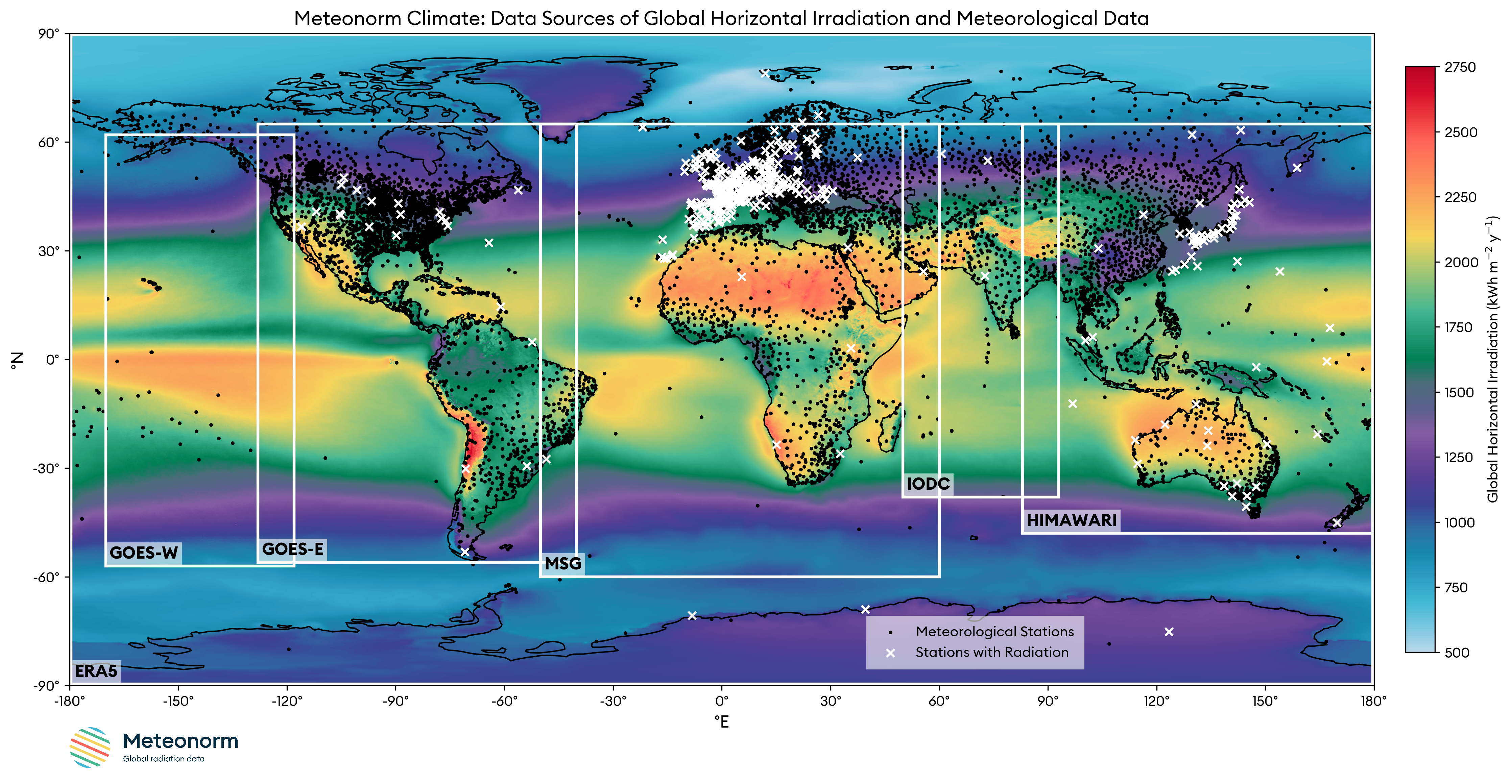 Figure 1: Global data coverage in Meteonorm, showing ground station locations
with (white crosses) and without irradiance data (dots), and the footprint of the five
geostationary satellites.
Figure 1: Global data coverage in Meteonorm, showing ground station locations
with (white crosses) and without irradiance data (dots), and the footprint of the five
geostationary satellites.
Ground Weather Station Data
Ground stations provide the most direct and accurate measurements of local weather conditions. They serve as the primary source of truth in our database.
Irradiance
The primary source for global horizontal irradiance (GHI) measurements is the Global Energy Balance Archive (GEBA) by ETH Zurich. This is supplemented with high-quality data from several national weather services (e.g., MeteoSwiss, DWD), as well as the Baseline Surface Radiation Network (BSRN) and the SURFRAD network.
- Approximately 400 high-quality irradiance stations are included in Meteonorm.
- Stations are carefully selected based on criteria such as quality and completeness.
Other Meteorological Parameters
For non-irradiance parameters, the station network is primarily based on the Global Surface Summary of the Day (GSOD) database from NOAA. For precipitation, this is enhanced with high-resolution data from national weather services like MeteoSwiss and the German DWD.
- Over 9,000 stations provide data for non-irradiance parameters.
- Included Parameters:
- Air temperature
- Dew point temperature
- Wind speed
- Precipitation
- Number of days with precipitation
Gridded Data
Gridded data provides complete spatial coverage, filling the gaps between ground stations.
Satellite Data
Satellite data is the primary source for irradiance in regions without dense station networks. Meteonorm incorporates data from five geostationary satellites, providing nearly global coverage (see Figure 1).
- MSG (Meteosat Second Generation): 2008 – 2023 (Europe, Africa, Atlantic)
- IODC (Indian Ocean Data Coverage): 2018 – 2023 (Indian Ocean region)
- HIMAWARI: 2018 – 2023 (East Asia, Australia)
- GOES-East: 2018 – 2023 (Americas, Eastern Pacific)
- GOES-West: 2011 – 2016 (Western Americas, Pacific)
To ensure consistency, the satellite data is homogenized to the 2001-2020 reference period using ERA5 data and is then adjusted with a large-scale bias correction based on trusted ground stations to account for regional biases.
ERA5 Reanalysis Data
For regions not covered by satellites (primarily the polar regions), Meteonorm uses the ERA5 reanalysis dataset as a fallback.
- The ERA5 data used in Meteonorm covers the climate reference period of 2001–2020.
- The following parameters are sourced from ERA5:
- Global horizontal irradiance
- Air temperature
- Dew point temperature
- Precipitation
- Wind speed
- Wind direction