

Meteonorm Observation
Meteonorm Observation provides near real-time measurements of solar irradiance. Unlike ground-based measurement systems, this product relies on satellite-based irradiance observations, providing consistent coverage, independent of local weather station availability.
Coverage
Meteonorm Observation is available on the whole globe. Quality is best for longitudes from 130°W to 180°E and latitudes from 60°S to 60°N, covered by four geostationary weather satellites:
- GOES-East
- MSG (Meteosat Second Generation)
- IODC (Indian Ocean Data Coverage)
- Himawari
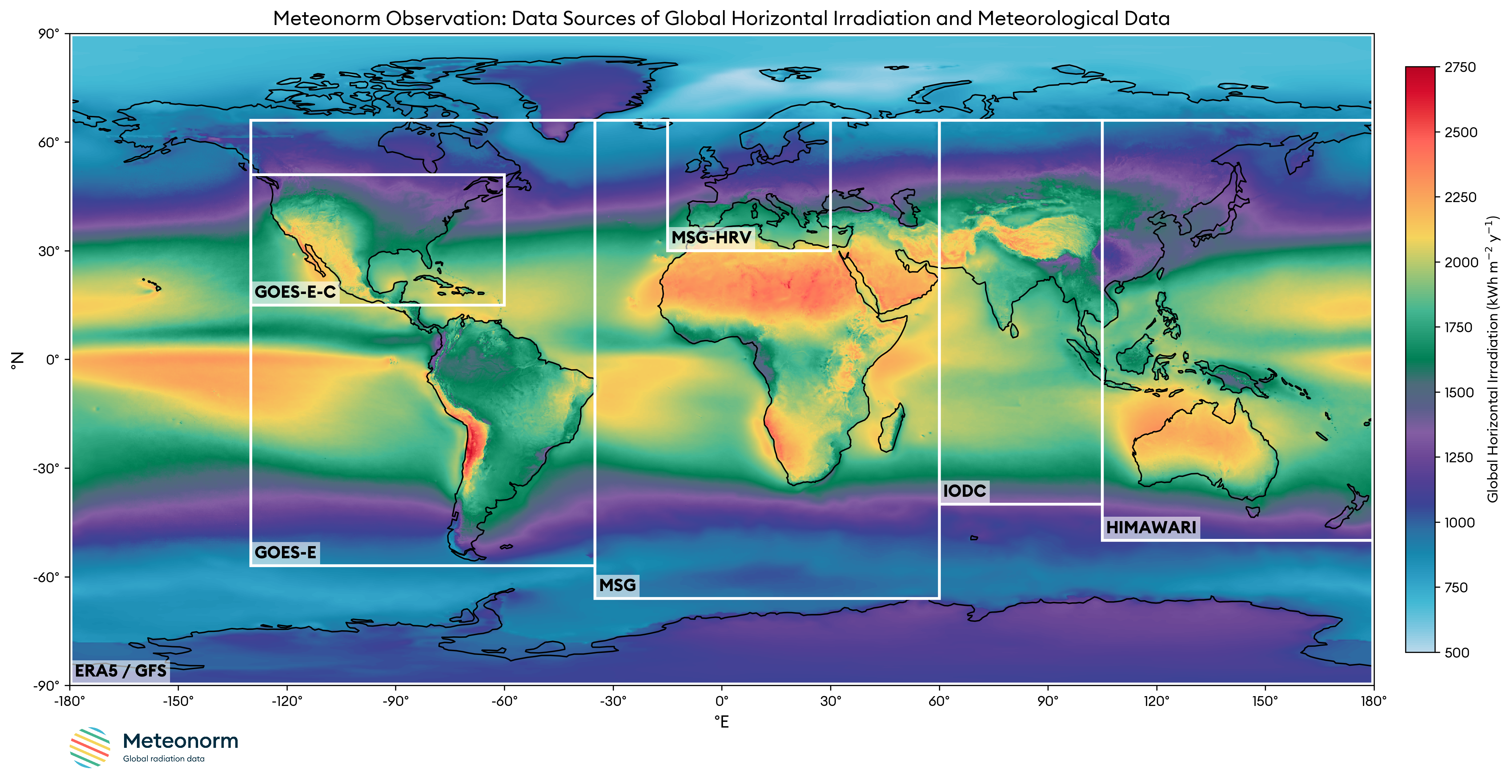 Figure 1: Global data coverage in Meteonorm Observation, showing the used bounding boxes
of the geostationary satellites including the high-resolution imagers (GOES-E-C and MSG-HRV).
ERA5 and GFS provide data in areas not covered by the satellites.
Figure 1: Global data coverage in Meteonorm Observation, showing the used bounding boxes
of the geostationary satellites including the high-resolution imagers (GOES-E-C and MSG-HRV).
ERA5 and GFS provide data in areas not covered by the satellites.
For locations that lack satellite coverage, as well as for the non-radiation parameters temperature
and snow_depth, we use the best available sources, depending on the location.
Temporal Resolution
Weather satellite data is available at temporal intervals of 10 to 15 minutes.
Spatial Resolution
Satellite data is projected onto a regular latitude/longitude grid with a standard resolution of 0.0625° (~5–7 km).
For enhanced coverage over North America and Europe, we leverage high-resolution imagers (GOES-E-C and MSG-HRV) to provide a superior 0.025° resolution product, which equates to approximately 2–3 km.
Accuracy
The accuracy of Meteonorm's satellite-based global radiation data is quantified using the relative root mean square error (rel. RMSE). The typical accuracy varies with the time resolution of the data.
| Time resolution | Typical Accuracy (rel. RMSE) |
|---|---|
| Hourly values | 20% |
| Daily values | 10% |
| Monthly values | 5% |
Satellite-based measurements are comparable in accuracy to high-quality ground-based pyranometers (radiation sensors), which typically are in the 5-10% range. A key advantage of satellite-based measurements is their immunity to common issues that affect ground-based measurement systems, such as soiling or disruptions.